What Is Point Fermin Known For?
Point Fermin is the bluff top southern tip of San Pedro, the coastal community at the far south end of the City of Los Angeles, where the street grid runs out above the entrance to the Port of Los Angeles. It is known for three things that sit within a few blocks of each other: a wooden Victorian lighthouse that has marked the point since 1874, a run of public bluff park along Paseo del Mar, and a cliff edge that the grid simply stops at.
What separates Point Fermin from the rest of San Pedro is that its ocean edge is almost entirely public land rather than private frontage. That one fact drives the views, the parking, the traffic and the rules about what can be built. One item is live right now and it is not about the bluff at all: Caltrans closes the Vincent Thomas Bridge on November 7, 2026 for sixteen months, which changes how everyone in San Pedro reaches Terminal Island and Long Beach.
Where Is Point Fermin and What Are Its Boundaries?
Point Fermin sits at the southern end of the San Pedro Peninsula in San Pedro, Los Angeles, directly west of the entrance channel to the Port of Los Angeles. There is no official City of Los Angeles boundary for Point Fermin as a neighborhood, and that is worth saying plainly, because the name gets used loosely in listings. In practice it means the bluff top blocks at the south end of San Pedro, anchored by Point Fermin Park at 807 Paseo del Mar and Angels Gate Park at 3601 Gaffey Street, both operated by the Los Angeles Department of Recreation and Parks in Council District 15.
Gaffey Street is the main north to south approach and the street that carries you down from the 110 Freeway. Paseo del Mar is the shoreline street that traces the top of the cliff. Cabrillo Beach and the Cabrillo Marine Aquarium sit around the point on the harbor side, at 3720 Stephen M. White Drive. If you can find those four addresses on a map, you have the neighborhood. Point Fermin falls inside the San Pedro Community Plan Area, and the Los Angeles Department of City Planning names Point Fermin among the areas the San Pedro Community Plan covers, alongside the Palisades, Vinegar Hill and Rancho San Pedro.
Point Fermin at a Glance
City and county | San Pedro, City of Los Angeles, Los Angeles County |
Council district | Council District 15, per the Los Angeles Department of Recreation and Parks |
Community plan area | San Pedro Community Plan Area, per the Los Angeles Department of City Planning |
Official neighborhood boundary | None. Point Fermin is a place name, not a mapped city district. |
Main streets | Gaffey Street north to south, Paseo del Mar along the bluff, Pacific Avenue inland |
Public parks | Point Fermin Park, Angels Gate Park, Joan Milke Flores Park, Wilders Addition Park, per the Los Angeles Department of Recreation and Parks |
Landmarks | Point Fermin Lighthouse, Korean Friendship Bell, Fort MacArthur Military Museum at Battery Osgood-Farley, Cabrillo Marine Aquarium |
Coastal rules | San Pedro Specific Plan, Ordinance No. 166,352, effective November 30, 1990, the implementing ordinance for the San Pedro Local Coastal Program |
Residential height limit | Two stories or 26 feet in the Specific Plan area, and 24 feet near designated public viewsites |
School district | Los Angeles Unified School District |
Live item for 2026 | Vincent Thomas Bridge full closure beginning November 7, 2026, per Caltrans |
How Is Point Fermin Laid Out?
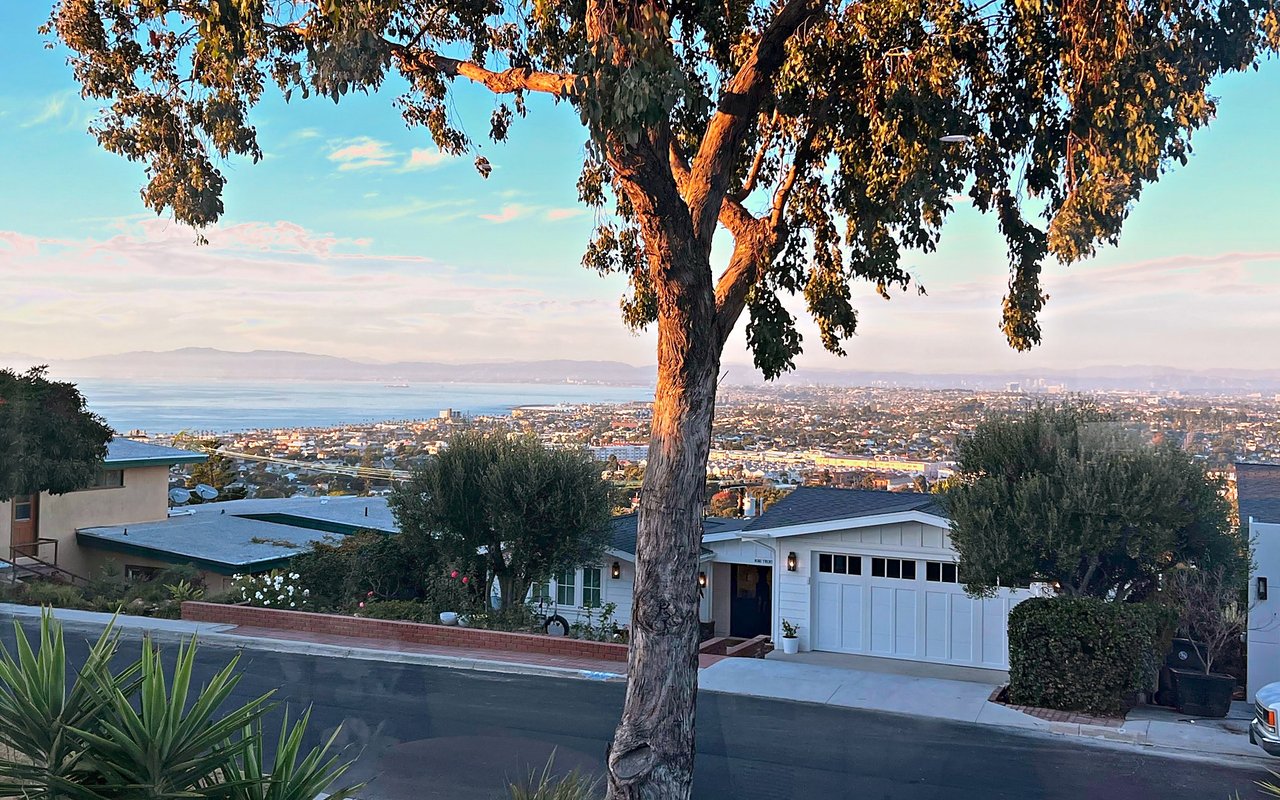
The layout of Point Fermin is a plain grid that meets a cliff. Numbered streets run east to west, climbing inland from the water, and named streets including Gaffey, Pacific, Alma and Carolina run north to south across them. Paseo del Mar is the last street before the drop, and for most of its length the ocean side of it is parkland rather than houses. The practical result is that along the stretches where the ocean side of Paseo del Mar is parkland, homes look at the water across public open space rather than across a neighbor's roof.
The grid is interrupted twice, and both interruptions are large. Point Fermin Park occupies the bluff top at the end of Gaffey Street, and Angels Gate Park occupies the high ground above it on the old Fort MacArthur upper reservation. Between them they absorb a substantial piece of the southern tip. A National Register nomination form for a proposed Point Fermin Historic District, hosted by the California Office of Historic Preservation, describes a district of 36.85 acres inside Point Fermin Park and Angels Gate Park, covering the Point Fermin Light Station and the Battery Osgood-Farley complex, with a period of significance running from 1873 to 1944.
That history is the reason the neighborhood reads the way it does. Point Fermin was a lighthouse station and then an Army coastal defense post long before it was residential, so the public land came first and the houses filled in around it. The land east of Paseo del Mar at the southeast corner is Sunken City, a section of bluff that failed and slid, and it remains fenced and closed to the public.
What Can Be Built in Point Fermin?
This is the question that catches buyers off guard, and the answer is a city ordinance most people have never heard of. The San Pedro Specific Plan, adopted as Ordinance No. 166,352 and effective November 30, 1990, is the implementing ordinance for the San Pedro Local Coastal Program, and it governs the portion of San Pedro inside the California Coastal Zone, which includes the Point Fermin bluff.
Under the San Pedro Specific Plan, residential buildings may not exceed two stories or 26 feet, measured from average existing natural grade to the highest point of the roof or parapet. Near designated public viewsites the limit tightens to 24 feet, although the plan allows the Director of Planning to permit more where the view would not be obstructed. The plan also requires that turn-out and viewsite areas along Paseo del Mar provide unobstructed ocean views, and it names public access trails at the point, including Sunken City to Point Fermin and Lighthouse to Point Fermin routes.
Read that as a buyer and it says something specific, though narrower than it first sounds. What the ordinance controls is the height of what goes up in front of you, not your view itself. A house there cannot grow past 26 feet, or past 24 in the viewsite areas, although the Director of Planning can allow more where a viewsite view would not be obstructed. The unobstructed view guarantee in the plan runs to the public turn-outs and viewsites along Paseo del Mar, not to any private parcel. Read it as a seller or a remodeler and it says the opposite: a third story is not on the table here, and a project inside the Coastal Zone can need a coastal development permit on top of the city's ordinary approvals. Either way, it is a parcel level question and it belongs in your numbers before you write an offer.
What Parks and Landmarks Are in Point Fermin?
Point Fermin Park is the center of the neighborhood. The Los Angeles Department of Recreation and Parks lists the park at 807 Paseo del Mar with hiking trails, walking paths, open space, shaded space, ocean views and picnic tables, open from 6:30 a.m. to 10:00 p.m., with walking access to Angels Gate Park, Joan Milke Flores Park, Wilders Addition Park, the Fort MacArthur Military Museum, the Korean Friendship Bell and the Point Fermin Lighthouse.
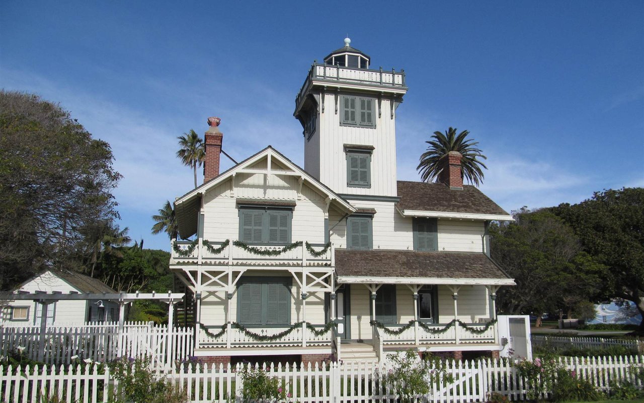
The Point Fermin Lighthouse has marked the south end of San Pedro since its beacon first shone on December 15, 1874, and it is a wood frame Victorian light tower with an attached two story keeper's residence. The United States General Services Administration reported that the United States Coast Guard transferred the lighthouse to the City of Los Angeles through a three party partnership with GSA and the National Park Service, in a ceremony held on the light's 144th anniversary.
Angels Gate Park, at 3601 Gaffey Street, holds the Korean Friendship Bell and the Fort MacArthur Military Museum at Battery Osgood-Farley, a concrete coastal artillery work from the First World War era. Around the point on the harbor side, Cabrillo Beach and the Cabrillo Marine Aquarium at 3720 Stephen M. White Drive are run by the Los Angeles Department of Recreation and Parks, and the aquarium runs tidepool walks at Point Fermin itself. For a neighborhood this small, that is an unusual concentration of public destinations, and it is also the reason weekend traffic on Paseo del Mar and Gaffey Street behaves the way it does.
What Schools Serve Point Fermin?
Point Fermin is served by the Los Angeles Unified School District. The California Department of Education school directory lists Point Fermin Elementary, Richard Henry Dana Middle and San Pedro Senior High among the Los Angeles Unified schools located in San Pedro. Point Fermin Elementary Marine Science Magnet is at 3333 Kerckhoff Avenue in San Pedro and describes itself as a STEAM program with a marine science emphasis and the only full magnet elementary school in the district with that focus.
One caution that matters more in Los Angeles than in the smaller South Bay cities: Los Angeles Unified assigns resident schools by address, and magnet and choice programs run on separate application processes. Nearby does not mean assigned. Confirm the resident school for a specific address with the district before you rely on it.
What Is Changing Near Point Fermin in 2026?
For Point Fermin specifically. It is about four miles north of the point, and nobody drives from Paseo del Mar to the 110 by way of Terminal Island. What changes is everything that crosses the harbor. Trips to Long Beach, to the Terminal Island employers and to the east side of the port move onto the Harbor Freeway and Pacific Coast Highway for sixteen months, and the traffic that used the bridge has to go somewhere. If you are buying in San Pedro this fall and your work or your family sits on the far side of the channel, drive the detour at the hour you would actually drive it before you commit.
The other live item is closer to home and slower moving. Sunken City remains fenced and closed, and the city has been working toward opening an upper viewing area behind a new safety fence. LAist reported on June 28, 2026 that the project is moving forward and that a new fence design requires coastal development permits, with no precise timeline. Nothing has opened yet, so treat Sunken City as closed when you walk the neighborhood.
Frequently Asked Questions About Point Fermin
Where is Point Fermin?
Point Fermin is the southern tip of San Pedro, a coastal community of the City of Los Angeles that sits at the far south end of the city, directly west of the entrance channel to the Port of Los Angeles. The neighborhood is anchored by Point Fermin Park at 807 Paseo del Mar and Angels Gate Park at 3601 Gaffey Street, both in Council District 15.
What are the boundaries of Point Fermin in San Pedro?
Point Fermin has no official City of Los Angeles neighborhood boundary, so the name describes the bluff top blocks at the southern end of San Pedro rather than a mapped district. In everyday use it covers the area around Point Fermin Park and Angels Gate Park, reached by Gaffey Street from the north and edged by Paseo del Mar along the cliff top.
Is Point Fermin walkable?
Yes. Point Fermin is walkable within itself, because its main destinations sit close together on a compact bluff top grid. The Los Angeles Department of Recreation and Parks lists walking access from Point Fermin Park to Angels Gate Park, Joan Milke Flores Park, Wilders Addition Park, the Fort MacArthur Military Museum, the Korean Friendship Bell and the Point Fermin Lighthouse. Grocery and everyday shopping sit north along Gaffey Street.
What school district serves Point Fermin?
Point Fermin is served by the Los Angeles Unified School District. The California Department of Education school directory lists Point Fermin Elementary, Richard Henry Dana Middle and San Pedro Senior High among the Los Angeles Unified schools in San Pedro. Los Angeles Unified assigns resident schools by address and runs magnet programs on a separate application, so confirm the assignment for a specific address with the district.
How tall can you build in Point Fermin?
Residential buildings in the Coastal Zone portion of San Pedro that covers the Point Fermin bluff are limited to two stories or 26 feet under the San Pedro Specific Plan, Ordinance No. 166,352, measured from average existing natural grade to the highest point of the roof or parapet. Near designated public viewsites the limit is 24 feet.
Can you visit Sunken City in San Pedro?
No. Sunken City, the failed section of bluff at the southeast corner of Point Fermin, remains fenced and closed to the public. LAist reported that the City of Los Angeles is working toward opening an upper viewing area and that the new fence design requires coastal development permits, with no precise timeline. Random Lengths News reported a public comment period on the fencing proposal in September 2026.
What is the Point Fermin Lighthouse?
The Point Fermin Lighthouse is a wood frame Victorian light tower with an attached two story keeper's residence standing on the bluff at the southern tip of San Pedro, and its beacon first shone on December 15, 1874. The United States General Services Administration reported that the United States Coast Guard transferred the lighthouse to the City of Los Angeles with GSA and the National Park Service.
How Do I Find Out What a Specific Point Fermin Property Is Subject To?
In Point Fermin the answer is almost always parcel level. Whether a view is protected, whether a second story is possible, whether a remodel triggers a coastal development permit and which viewsite rule applies all turn on the lot, not on the neighborhood. Send me a block or an address and I will tell you where it sits relative to the San Pedro Specific Plan viewsite areas, what the 26 foot and 24 foot limits mean for that parcel, and how the Vincent Thomas Bridge closure changes the drive from that address for the next sixteen months. Call or text Michael Majid at 310-592-1243, or start with the South Bay property search.
If you are weighing the harbor side of the South Bay against the Peninsula, the South Bay neighborhood pages have the local detail, and buyers shopping here often run Rancho Palos Verdes and Palos Verdes Estates in the same search.
Before you Buy or Sell, Get the Intel.
Sources: Caltrans District 7, 16-Month Closure of Vincent Thomas Bridge Now Set for November 7, news release dated September 25, 2026, accessed October 20, 2026. Port of Los Angeles, Vincent Thomas Bridge Deck Replacement Project, accessed October 20, 2026. City of Los Angeles Department of City Planning, San Pedro Specific Plan, Ordinance No. 166,352, effective November 30, 1990, accessed October 20, 2026. City of Los Angeles Department of City Planning, San Pedro Community Plan, accessed October 20, 2026. City of Los Angeles Department of Recreation and Parks, Point Fermin Park, accessed October 20, 2026. City of Los Angeles Department of Recreation and Parks, Angels Gate Park, accessed October 20, 2026. City of Los Angeles Department of Recreation and Parks, Cabrillo Marine Aquarium, accessed October 20, 2026. United States General Services Administration, Point Fermin Lighthouse Deed Transfers to City of Los Angeles, dated January 15, 2019, accessed October 20, 2026. California Office of Historic Preservation, Point Fermin Historic District National Register nomination form, accessed October 20, 2026. California Department of Education, California School Directory, accessed October 20, 2026. Point Fermin Elementary Marine Science Magnet, Los Angeles Unified School District, accessed October 20, 2026. LAist, How San Pedro's Sunken City fell into the ocean and why you might be able to visit the remnants, dated June 28, 2026, accessed October 20, 2026. Random Lengths News, Sunken City Fencing Project, Public Comment, dated September 8, 2026, accessed October 20, 2026. No MLS listing data is reproduced in this post.